TRAIL MAPS

Trail maps austintown ohio

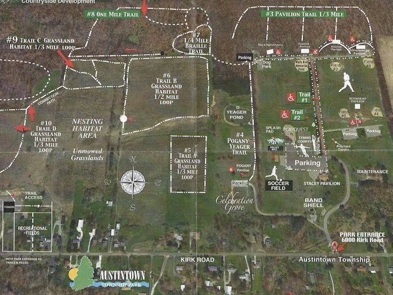
Lots of hiking opportunities from our one-mile loop hiking trail in our western streamside forest section of Township Park, a 1/4 mile Braille Trail around “Corll Meadows” with informational signage in both Braille and raised lettering, a half-mile mulch trail behind our pavilions to metered walking maps available for pavement walking for easy footing and rehabilitative walking. Click here to download a copy of the new Park Trail Guide. For unpaved walking, there is a 1/4 mile mulch trail accessible behind the four open pavilions.


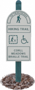
To access the 1-mile-long loop Hiking Trail or the 1/4 mile loop “Corll Meadows Braille Trail”, enter from the gravel parking lot at the northwest corner where the pavement ends. A trailhead sign will direct you along the short path through the trees to the meadow opening and the trailheads.

Park Trail Guide
Austintown Trail Maps

The “Corll Meadows” Barille Trail features:

  • A limestone aggregate base suitable for walkers and soon-to-be for wheelchairs.
  • It is close to bikes and skates.
  • 9 interpretive signs with both Braille & raised wording and graphics.
  • A nylon guide rope along the entire 1/2 mile loop

The Mile Loop Hiking Trail is a hard pack clay surface. The terrain varies from easy to moderate walking. Special features include:

  • Stepping stone stream crossing
  • Two sets of wooden steps at the ravine area and a wooden crossover bridge
  • Directional trail markers also usable with an interpretive guide

An overview of all Trails is shown, and you can click it for a high-resolution view.

Contact Austintown Park Department

Trail Maps Park Dept Form Message

Share by: